Blue Ridge Running
Julian Price Park
The Julian Price Memorial Park is a part of the Blue Ridge Parkway. The National Park Service (NPS) does a good job of managing the Parkway. Price Park features three distinct trails as well as some important trail connections. Elevations in the park vary from 3400 feet to 4000 feet. Most of the trails are single track and runnable, though there are some exceptions.
The trails that are totally contained in the park are the loops of Price Lake Trail, Boone Fork Trail, and Green Knob Trail. The northeast terminus of Tanawha Trail is near the Price Lake amphitheater. The Mountains-to-Sea trail goes through the park on Tanawha and Boone Fork Trails and then continuing to the northeast to connect with Moses Cone Park near Trout Lake.
For more information on the park, visit the NPS website by clicking here. Maps are available for download. But, note that the discrepancies of distances on the map and on the park signs are the reason that this website was created.
Distances
With one exception, I think that I have measured all of the trails in Julian Price park that are going to get measured. Here is what I found:
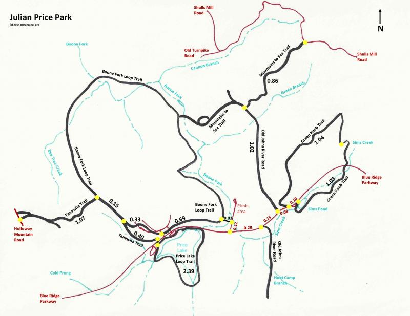
Price Lake Trail (2.39 mile loop) - this trail is a mix of ashpalt, groomed gravel, mud, roots, and good single track.
0.12 mi. Boat Rental driveway to Tanawha Trail connector
0.22 mi. TT connector to end of campground -- and the asphalt
0.25 mi. End of campground to middle of Parkway bridge
0.73 mi. Parkway bridge to footbridge #8
1.07 mi. Footbridge #8 to Boat Rental driveway
Connector between Price Lake Trail and Boone Fork Trail
0.07 mi. Price Lake Trail to Tanawha Trail trailhead
0.02 mi. Tanawha Trail to Boone Fork Trail
Old John's River Road: 1.02 miles from Blue Ridge Parkway to Mountains-to-Sea Trail. The southern incarnation of OJRR from BRP to the park boundary may get measured in the future.
Mountains-to-Sea Trail: 0.86 miles from Old John's River Road to Shull's Mill Road
Boone Fork Trail - this trail is partly runnable; I have only run the full loop twice and regretted doing so each time. The southern and easterly sections are great sections: mostly single track with typical dirt, roots, mud, and gravel. The far side of the loop (about 1/2 mile west of Tanawha Trail to about 1/2 mile west of the Start/Finish of the marked loop) is beautiful and good for hiking. But, that section includes too many rocks and one ladder. So, I do not plan on measuring the unrunnable section. Here is the remainder:
0.12 mi. Blue Ridge Parkway to Boone Fork Trail trailhead bridge
0.03 mi. Boone Fork Trail trailhead bridge to Boone Fork Trail S/F
0.69 mi. S/F clockwise to 2nd road crossing & start of asphalt trail
0.22 mi. Second road crossing to 3rd road crossing and end of asphalt/campground
0.11 mi. Third road crossing to Tanawha Trail junction (joins from left side)
0.15 mi. Tanawha Trail junction to Tanawha Trail turnoff
Tanawha Trail - this is just the northeastern end of the great trail. There is some overlap with Boone Fork Trail. The Tanawha Trail tab has a complete listing. Here are the portions within Julian Price Park:
1.07 mi. Holloway Mountain Road to Boone Fork Trail
0.15 mi. BFT junction to right-turn to leave Boone Fork Trail
0.40 mi. BFT to northeastern terminus
Green Knob Trail (2.22 mile loop) - this is a tough, gorgeous trail with a really steep ascent up Green Knob when running in the clockwise direction. The trail is almost all single track with mud, roots, some pasture (be nice to the cows), stairs, and creek crossings.
0.10 mi. Trailhead at Sims Pond to SW trailhead (through parking area and along BRP)
0.09 mi. SW trailhead to first fenceline (leavng woods, entering meadow)
0.53 mi. Fenceline at meadow to fenceline at crest of Green Knob
0.42 mi. Fenceline at crest to fenceline at bottom of pasture entering woods
1.08 mi. Fenceline at pasture to trailhead at north end of parking area
Blue Ridge Parkway
0.29 mi. Price Park Picnic Area driveway to Old John's River Road
southern extension to Misty Creek (at the red barn)
0.13 mi. Between the two Old John's River Road intersections
0.08 mi. Old John's River Road to Green Knob Trail (SW trailhead)
0.10 mi. Between Green Knob Trailheads (Sims Pond trailhead is
measured from the northeastern side of the parking area)
Map
A map of the measured sections is shown below. If you would like a higher resolution version, click here.

Copyright 2020 C.Squires. All rights reserved.
